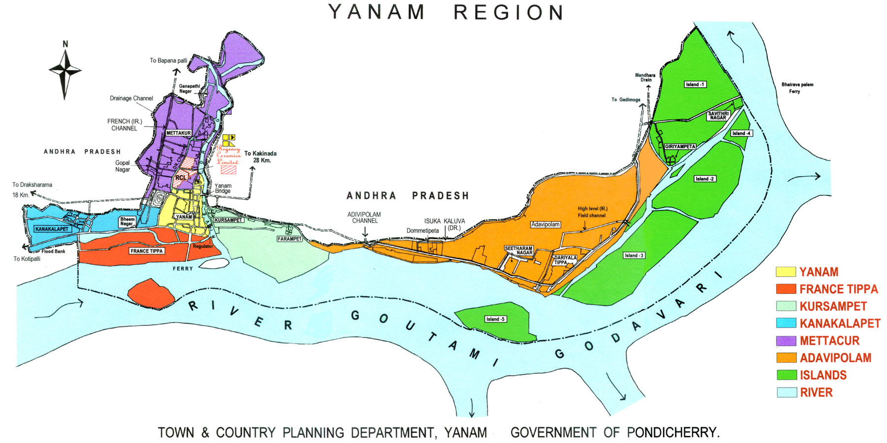
General Information About Yanam
APPROACH
-
There is no railway line in Yanam region.
The nearest Railway Station is at Kakinada
(Head quarters of East Godavari District) which is 26 kms
away on the east. It is an important trade centre and port townand there
is a District road on the west of Ramachandrapuram and Rajahmundry.
There are number of buses from Kakinada to Yanam running for every 10 Minutes.
There are also buses running from Yanam to Rajahmundry, which is on the
main line of railway route, Ramachandrapuram, Visakhapatnam.
SOIL
-
It is occupied by alluvium consisting
of sand clay and gravel. Ground water occurs
both inder water table and confined conditions in the granular beds
in the alluvial deposits. It is developed by means of shallow filterpoints
wells within a depth of nine metres. The soil is greyish black and
is essentially clayey in composition. A few thin layers
of sandy clay or sand, not exceeding
0.3 metre in thickness are intercalated with the clayedsoil. The river
sands on the bank of Gautami Godavari consists of predominently
of quartz, felspar and lucovite mica. A few grains
of monazite are also foundin the black streaks.
-
A bore hole dug by the villagers near
Mettakuru for water supply is reported to have
passed through the following strata down to a total depth of 55 metres(170
feet approximately).
-
Sandy soil .. 3 m. thick
-
Clayey soli .. 6 m. - 8 m. thick
-
Sandy soli .. Remainder down to
55 m.
There are no minerals
of economic value in the region.
IRRIGATION
-
Yanam received irrigation water through
Bank Canal which starts from Doweleswaram Head
works (Sir Arthur Cotton Barrage on the river Godavari down
stream Rajahmundry). This canal runs towards east upto Pillanka, asmall
village near Yanam. From Pillanka water is brought to Yanam through
a small canal popularly known as "French Channel"
built by an agreement entered in 1949 between
the then French Government and the Government
of India. This canal serves the irrigation as well as drinking
water needs of the ares west of Coringa River.
-
After Merger, steps were taken to provide
irrigation facilities for about
560 Ha. of dry land in the eastern side of the Coringa River byproviding
a new irrigation canal called "Adivipolam Channel" from the tail
end of Tallarevu south channel and at the starting point of Nilapalli
channel on the right side. the work was taken for executionby the
Andhra Pradesh Public Works Department as a deposit work in 1964 and was
completed and commissioned in June 1966. The water from this channel
is used for drinking purpose also, as in the case of French Channel.
CLIMATE AND RAINFALL
-
It experiences a climate which is characterised
by high humidity over 70% in the mornings and
over 60% in the evenings throughout the year, an
appressive summer season and a good rainfall. It enjoys the benefitof both
the South-West and North-East Monsoon. During a year on an
average, there are about 60 rainy days i.e. days with
rainfall of 2.5mm or more.
TEMPERATURE
-
From February, temperature start rising
rapidly till May which is the hottest month
with the mean maximum around 37 degree C and mean minimum around
28 degree C. Humidity being high, the heat is very trying. The maximum
temperature on some days in May or early June before the onset
of
the south-west monsoon may even touch 47 degree C. The sea breeze,
however afford some relief in the afternoons. Similarly
pre-monsoon Thundershowers may also bring welcome
relief on some days. With the onset of
the monsoon in June the temperature falls rapidly and
remains almost steady till September. In this season
mean maximum temperature is around 32 degree
C and night temperature fall rapidly till December
or January when day temperature is around 27 degree C and
night temperature around 19 degree C. Sometimes the minimum temperature
may reach as low as about 14 degree C. December and January
are the coolest months.
HUMIDITY
CLOUDNESS
SURFACE WINDS
-
In the summer season winds blow from
directions between south east to south west.
During the monsoon season, they blow mainly from south west
to west. During October to February, winds are usually fromnorth-east
in the mornings, veering towards south-east in the afternoons.
Winds are generally light to moderate during the whole year.
SPECIAL WEATHER PHENONMENA
-
The storms and depressions which
form in the Bay of Bengal in the pre-monsoon
month of May, and during September to Novembe, cross the
east coast, and affect the region and the neighbouhood, causingthunder-storms,
heavy rain, tidal waves and strong winds. Occassional
thunder-storms associated mainly with the onset of the south-west
monsoon occur in April, May and June.
The Yanam - Yedurlanka Ferry
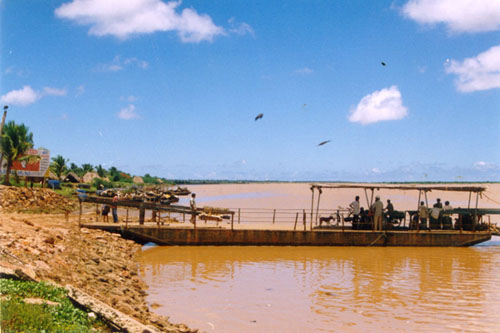
Daily above Ten Thousand passengers
are travelling to and fro on this 'Panti'. The people from Konaseema area
under the Amalapuram Constituency of East Godavari District are mainly
using this river way for reaching Kakinada,the District HeadQuarters.
This river called Gauthami Godavari
is one of the branches of the main river Godavari. It enters the Bay of
Bengal after crossing around 12 Kms.
The minimum capacity of the Panti
can hold is 15 Tonnes.It supports the two wheelers, three wheelers as well
as four wheelers excluding heavy vehicles.
Per trip, it carries roughly 200
passengers along with vehicles. The time of journey depends on the river
flow.Generally, it takes 15 minutes to cross from one end to another.
Now, the Govt. of AndhraPradesh with
the assistance of ONGC, WorldBank Funds, Pondicherry Govt., Central Govt.
and the donations from the farmers & markeing committies,is constructing
a Bridge across this river.
The estimated cost of the construction
is roughly 120 crores.
The Navayuga Engineering Constructions(NEC)
of Visakhapatnam has taken the contract to build the bridge in the stipulated
time of 36 months. The foundation stone was laid by
Shri G.M.C.BalaYogi, Hon'ble LokSabha
Speaker.
<